Posts in category 'Why We Love Central Oregon'
Subscribe and receive email notifications of new blog posts.
 RSS Feed
- 2026 | 65 Posts
- 2025 | 103 Posts
- 2024 | 110 Posts
- 2023 | 72 Posts
- 2022 | 52 Posts
- 2021 | 70 Posts
- 2020 | 84 Posts
- 2019 | 38 Posts
- 2018 | 48 Posts
- 2017 | 39 Posts
- 2016 | 31 Posts
- 2015 | 10 Posts
30
Tumalo Falls is Bend's Waterfall
Popular Tumalo Falls is Among Most Tourists' Must See Destinations
 Tumalo Falls has always been a destination for people visiting Central Oregon. The short drive out of Bend followed by a short walk can give tourists the opportunity to see a beautiful local waterfall and the location of roughly 1/2 of Bend's water supply. Most people stop at either the base of the falls, or will climb the 1/4 mile up to the overlook at the top of the falls. But there is a fabulous trail upstream along Tumalo Creek that takes hikers past several beautiful waterfalls and eventually leads to Happy Valley meadow in which a merger of several trails and roads provide for miles of opportunities to recreate using the Tumalo Trail System.
It has been seven years since we last hiked to Tumalo Falls. That last time the road to the falls was closed due to the piping project for the the city of Bend in the Bridge Creek watershed. At that time we parked at Skyliner's Trailhead and hiked around to Tumalo Falls and then hiked up Bridge Creek, eventually joining with the main North Fork Trail just south of Happy Valley returning down the main trail and eventually back to our car. During that trip we saw almost no one.
It was very different September 26, 2020. Parking along the road was crowded and rather than hike the normal way up the North Fork Trail, we decided to take the loop around using the Farewell Trail which starts on the east side of the Falls and switchbacks up the hill bordering Tumalo Falls on the east, eventually joining with Mrazek Trail, then to Metolius-Windego Trail and then in Happy Valley, connecting with the North Fork Trail; the whole hike was slightly more than 10 miles and gave us a much different perspective of the area.
Unlike our last experience seven years ago, however, we were very surprised at how busy the trail was - not with hikers, but with mountain bikers. During our 10 mile loop, we stepped aside multiple times as mountain bikers passed by. We estimate we saw over 100 bikers that day and obviously during the summer season, there must be many, many more that will ride over these trails. The Tumalo Trail System borders the Three Sisters Wilderness where bicycles are not allowed and the system is extremely extensive and must be well enjoyed by the mountain bike community in Central Oregon.
 |
 |
.JPG) |
 |
.JPG) |
22
Is The Obsidian Trail Worth the Wait?
Hikers Must Reserve Their Day Months in Advance

We had heard about the Obsidian Trail for years, and how hard it is to reserve a time to hike it. Located in the Willamette National Forest off Hwy 242 (McKenzie Pass), access to the Obsidian Trail is limited - first due to Hwy 242's annual closure from October through the middle of June - and second due to demand for the hard to get passes which limit use to 30 day hikers and 40 overnight visitors. We reserved our time 2 months in advance, hoping the weather and wildfires would cooperate with our hike. The Green Ridge Fire and the Lions Gate Fire were both burning On September 5, 2020 when we took our hike, but neither had yet exploded into the heavy wildfires that burned much of McKenzie Canyon and caused the choking smoke that is still impacting Oregon.
We arrived very early at the trailhead, just past sunrise, and were surprised how few cars were parked in the parking lot. But this does make sense. When you have to reserve your time so far in advance, scheduled recreational hikes may have to give way to changes in financial or personal circumstances thus bringing use of the trail to even fewer people. During our Obsidian Trail hike, we past two parties who had spent the night in the area and were hiking out plus were past by a party packing in with horses. Other than these people, we saw no one else on the Obsidian Trail except for a party hiking in at the end of the day as well as a second group of people packing with horses. However, the Obsidian Trail loop, if taken, does utilize the Pacific Crest Trail where we saw a number of day users and backpackers.
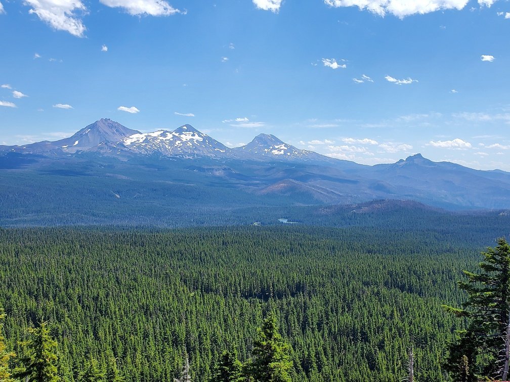
The Obsidian Trail is named for the obsidian stones and pebbles which are very evident in certain areas of the hike - and which will glitter beautifully when the sun hits them. The hike gains 2139 feet in elevation and provides for stunning views of North and Middle Sister, including vistas of Collier Glacier. Obsidian Falls and wonderful lodgepole and hemlock forests are also treats to see along the way. Lava fields, mountain meadows, small alpine lakes and, when the loop is followed, views of Mt. Washington, Three Fingered Jack and Mt. Jefferson are also visible. We also saw the smoke from the Green Ridge Fire, but it did not impact our enjoyment of the area during the day. The full loop was just under 12 miles, but we did take a side trip up the flank of Middle Sister, hoping to find the trail which we have heard exists to the summit, but failed to locate it.

 |
 |
 |
1
Sisters Mirror Lake to Wickiup Plains Hike Offers Lakes and Mountains
Last Saturday, August 29th, we decided to take an easier hike to Sisters Mirror Lake. Located just south of Devil's Lake off South Century Drive, the Sisters Mirror Lake trail head has limited parking space, but we easily found a spot on the highway. The 3 plus mile hike into Sisters Mirror Lake was a fairly easy walk in old growth forest with an elevation gain of between 600 and 700 feet. The lake itself is one of a series of small high elevation lakes, each with its own charm and privacy. We saw just a few people on this trip - many with packs to spend the night.
After enjoying visiting the various lakes, including Lancelot, Camelot, Needle and several unnamed lakes and snacking on wild blueberries that were at their peak of ripeness, we traveled on the Pacific Crest Trail, which skirts Sisters Mirror Lake, to Wickiup Plains having heard that the Plains provide wonderful South Sister views. That statement was proven true when we stepped out of the old growth forest and saw South Sister. The south side of South Sister rises dramatically up from the Wickiup Plains and dominates the skyline. The view is truly magnificent and with each step closer to the Wickiup Point, the view grew larger.
We took the Wickiup loop back, connecting with the Devil's Lake trail before taking the Elk Lake trail back to connect with the Sisters Mirror Lake trail roughly 1/2 a mile before the parking lot. Wonderful views of Broken Top were visible on this part of our hike before we entered the old growth forest again. All in all, our relatively easy hike ended up being in excess of 12 miles - but it was well worth it for the wonderful surprises we saw. We have lived in Bend since 1985 but have never heard of Wickiup Plains before. What a surprise!
 |
 |
17
Scott Mountain in the Mt. Washington Wilderness is a Great Hike

McKenzie Pass (Hwy 242), connecting Central Oregon with the Willamette Valley, is opened for such a limited time each year that many of the available hikes and places of beauty are not as visited as those located off Cascade Lakes Highway in the 3 Sisters Wilderness. But the hikes off McKenzie Pass offer views of the Cascades that cannot be seen from other locations in Central Oregon - including vistas of the west side of the 3 Sisters (and Little Brother) plus Mt. Washington, Mt. Jefferson and Broken Top.
Our hike up Scott Mountain started at Scott Lake and then passed through old growth forest to Benson Lake and then further to Tenas Lakes before climbing more steeply around the back of Scott Mountain to the summit (a total of 1300 feet elevation change in around 4.1 miles). Wild huckleberries were abundant as were thousands of orange California Tortoiseshell butterflies. The view from the top of Scott Mountain was fabulous - both toward the Cascade peaks but also west toward the Willamette Valley. The foundation of the old lookout tower was still in place, but we saw hardly anyone on this hike to the peak and absolutely no one at all as we came down the long way around by Hand Lake (where we saw a few families playing in the shallow water) back to Scott Lake (the huckleberries on this stretch of trail were hardly touched - and we wished we had thought to bring a bucket to gather some for home). The walk along the lava flow before we reached Hand Lake was interesting and full of the butterflies. All in all, the total hike was a bit more than 9.7 miles with our side trip to Hand Lake's shore.
 |
 |
 |
 |
13
Hike to Three Fingered Jack in the Mt. Jefferson Wilderness

For those who have never hiked in the Mt Jefferson Wilderness, the feeling of the forest is different than that of the 3 Sisters Wilderness. And the hike to the east side of 3 Fingered Jack through Canyon Creek Meadow is a lot of fun. The Canyon Creek Meadow hike, which can be done on its own, is a 4.5 mile fairly easy loop taking hikers through the recovering 2003 B&B Complex burn through the beautiful, wildflower filled meadow, complete with the creek and stunning views of 3 Fingered Jack. A 3 mile round trip spur hike off the Canyon Creek loop will lead to a viewpoint on a flank of 3 Fingered Jack. This point provides fairly steep elevation change, loose stones and pumice on the trail and views toward the 3 Sisters, Mt. Washington, Mt. Jefferson, the meadow just hiked and the turquoise Cirque Lake created by glacial runoff. If you look carefully enough, you may be able to spot the mountain goats perched on unbelievable ledges on the rock face of 3 Fingered Jack.
Our trip back to the trail head involved another .7 mile spur off to Wasco Lake which was also mostly burned in the B&B Complex fire. Although not heavily traveled, the hike off to Wasco Lake also can provide access to Pacific Crest Trail and further lakes and vistas within the Mt. Jefferson Wilderness.
 |
 |
 |
 |